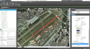
Geospatial Expeditionary Planning Tool (GeoExPT) is a decision support tool for mission planners and engineers to provide the means to create geospatially accurate base layout plans, meet beddown requirements, automate aircraft parking, and analyze and repair airfield damage for optimal selection of the Minimum Airfield Operating Surface (MAOS) in accordance with Department of Defense (DoD) standards.
Aircraft Parking
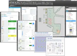
GeoExPT provides various aircraft parking tools to allow users the ability to create parking plans based on aircraft parking standards and Air Force Instruction (AFI) guidelines. Aircraft can be parked manually, automatically, or any variation between with mixed airframes on any parking surface. Marking lines and standoff distances can easily be controlled during placement.
GeoExPT provides civil engineers and logistics planners with tools that allows them to establish the design and plan for sustainment of expeditionary bases.