
Aircraft Parking
GeoExPT gives users the ability to automatically create parking plans based on established aircraft parking standards and AFI guidelines. These parking plans are created in accordance with military and DoD standards, and these automated aircraft parking plans are made on designated surfaces with flexible options and multiple solutions. GeoExPT uses flexible options and multiple solutions with aircraft parking plans.
PARKING OVERVIEW
With GeoExPT, you can
- Create parking plans based on military guidelines and restrictions
- Automatically create all marking lines, including turning radius lines
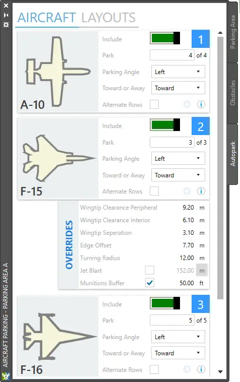
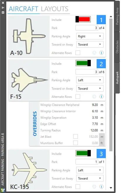
- Take into account wing tip clearances, munitions standoffs, and jet blast during aircraft parking
- Allow both automatic placement and manual placement modes for aircraft parking
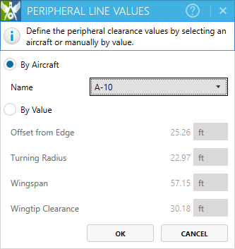
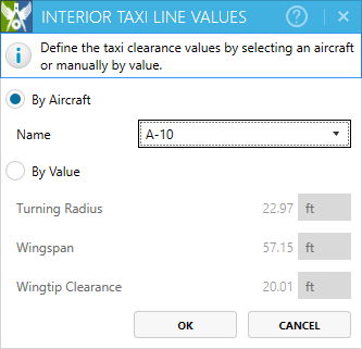
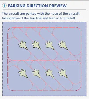
- Analyzing and ensuring that options for aircraft parking direction, separation and standoff distances, aircraft turning radii, peripheral lines, taxi lines, peripheral clearance, and peripheral taxi lanes are properly implemented
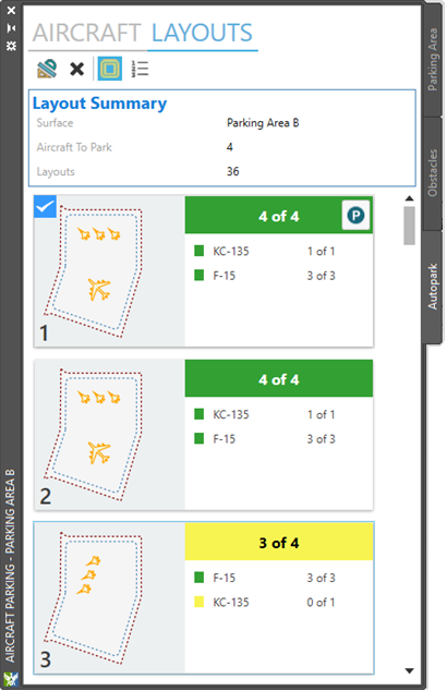
- Preview parking layouts and visualization of taxilane clearances
- Define routes from parking areas to runways
GeoExPT uses the appropriate military and DoD standards to create automated aircraft parking plans on designated surfaces with flexible options and multiple solutions. Whether you are trying to determine if there is enough ramp space for several C-17s or multiple F-22 squadrons, GeoExPT provides multiple plans illustrating the aircraft, including their standoff distances, marking lines, peripheral taxi lines, etc. GeoExPT considers the unique turning radii, wing tip clearances, munition standoffs(i.e. Quantity Distance), jet blast, and other factors to automatically establish optimal plans for selection.
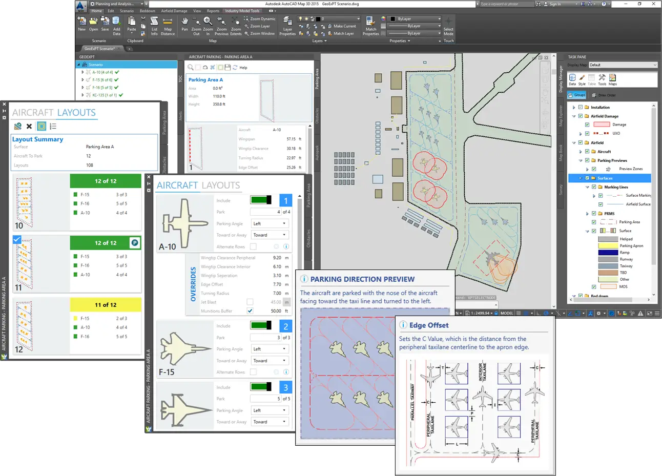
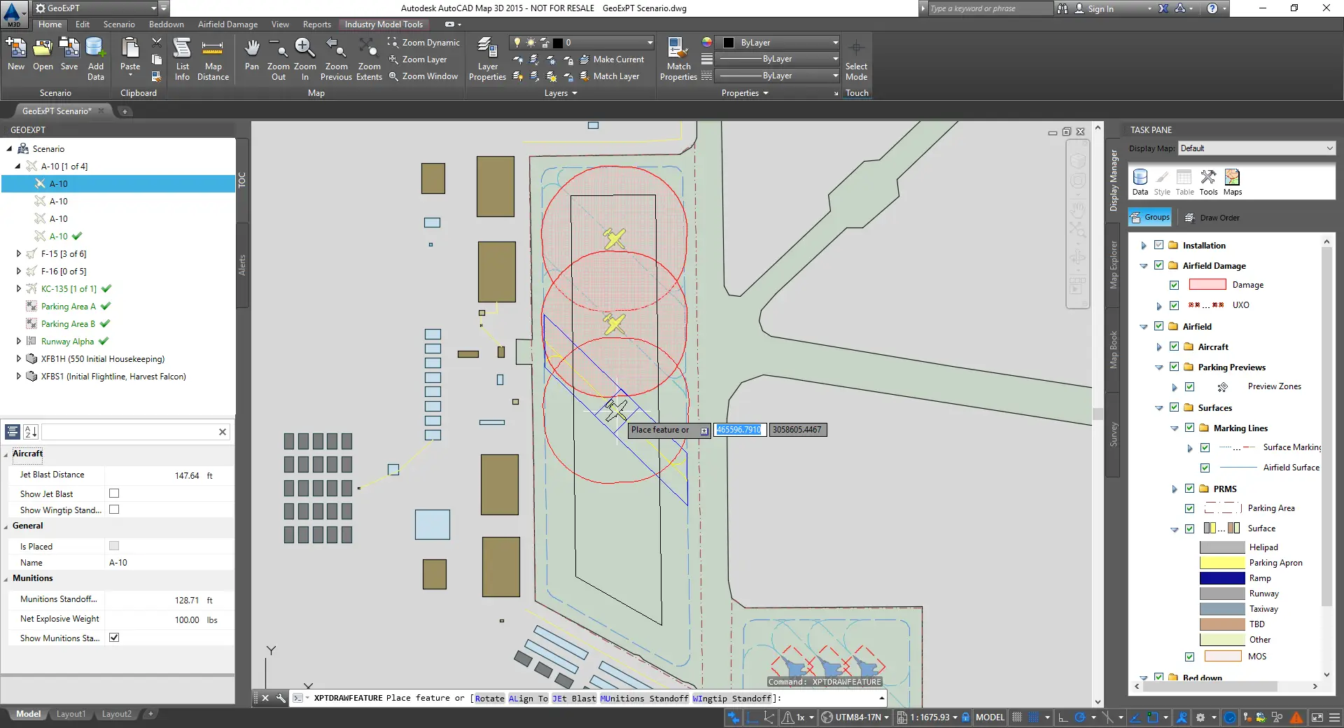
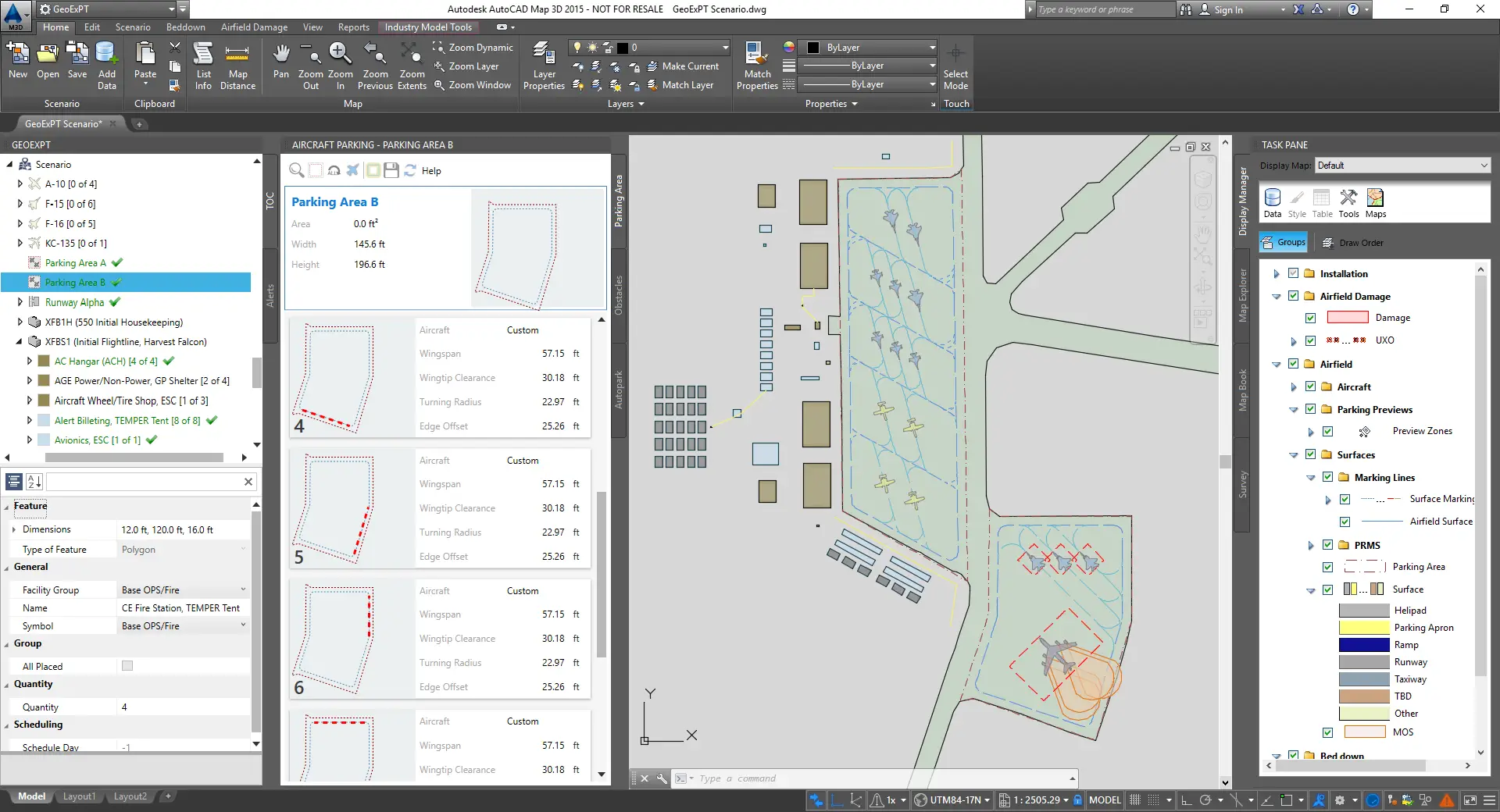
Aircraft parking begins with defining a parking surface. When peripheral or taxi lines are required, GeoExPT takes into account all of these settings established for the above mentioned parking factors. When manually parking aircraft, GeoExPT then displays feedback to the user that estimates standoff, marking lines, and taxilines. Users are also able to rely on GeoExPT’s automated parking algorithm’s to develop parking plans that can park all types of aircraft in a single instance. These layouts can be previewed prior to placement to select the optimal solution.
GeoExPT’s aircraft parking algorithms and tools provide operators with a quick and efficient decision support and planning tool. The task of placing aircraft assets becomes more complicated when airfields are host to a variety of allied military, nongovernmental organizations, and commercial air activities. GeoExPT provides an aircraft management tool for ensuring all requirements and constraints are considered as part of the airfield assessment.
Additional Features
Aircraft Database
GeoExPT’s database includes over 200 aircraft, each unique with its own attributes and scaled shape. Aircraft can be manually or auto parked on designated parking areas on the map.
Parking Areas and Surfaces
Airfield Surfaces and Parking Areas are fundamental requirements of aircraft parking plans. A surface is a designated location for aircraft operations including but not limited to; aircraft maintenance, landing, aircraft take-off, and taxiing to and from the runway. Parking Areas are designated as areas specifically designed for aircraft parking operations. GeoExPT has several predefined surface type options that comply with the Spatial Data for Facilities, Infrastructure, and Environment (SDSFIE) standards.
Manually Park Aircraft
Aircraft parking begins with defining a parking surface. When peripheral or taxi lines are required, GeoExPT takes into account all of these settings established for the above mentioned parking factors. When manually parking aircraft, GeoExPT displays feedback to the user that estimates standoff, marking lines, and taxilines.
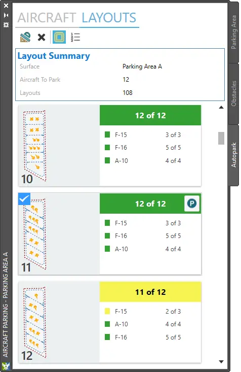
AutoPark Aircraft
GeoExPT uses a process called “Autopark” to determine the location, position, spacing, and pattern of the aircraft on a parking area based on aircraft properties. Users are able to rely on GeoExPT’s automated parking algorithm’s to develop parking plans that can park all types of aircraft in a single instance. These layouts can be previewed prior to placement to select the optimal solution.
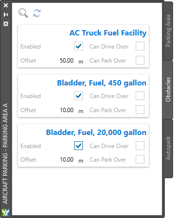
Obstacles and Munitions
When parking on real world surfaces, GeoExPT must take into account obstructions or obstacles that limit the available parking space. For instance, there may be obstructions you can generally drive over and obstacles that may not allow you to park over or nearby. As a result, the parking algorithms consider all of the aircraft properties (i.e. wingtip clearance, jet blast, munition standoff, etc.) and obstacles to determine the most optimal parking plan.